Geography
Principles of the Geography Curriculum
Intent: Why do we teach what we teach?
The United Curriculum for geography provides all pupils, regardless of their background, with:
- Relevant and coherent substantive knowledge of the world that is built gradually using subject-specific pedagogy from EYFS to Year 6 and beyond.
- Substantive knowledge – both conceptual and procedural – is selected to build pupils’ understanding of three geographical vertical concepts:
- Space and Place-Developing an understanding of space through ideas related to location, distribution, pattern and distance. Developing a sense of place and character through ideas related to identity, home, community, landscapes and diversity, and examining a range of case studies from across the globe.
-
- Physical Processes-How the Earth’s natural processes shape and change the surface of the Earth. This includes both Geology & Earth Science aspects, such as the structure of the Earth and physical features we see on the land, as well as Environmental Science aspects, such as the weather and our changing climate. Both of these are threaded through the science curriculum too.
-
- Human Processes-The processes and phenomena that are caused by or relate to people, including out Use of Resources; the distribution and changes to Population & Communities; and the features of Economy & Development.
- A balanced view of the countries of the world, to address or event preempt misconceptions and negative stereotypes.
- Explicit teaching of core disciplinary knowledge, and the ability to approach challenging, geographically-valid questions. Geographical enquiry skills have been sequenced across the year groups and, where appropriate, review and build on relevant knowledge that is first taught in mathematics or science, such as interpreting line graphs or setting hypotheses.
- Opportunities to undertake fieldwork, outside the classroom and virtually. Fieldwork is purposeful, and either gives pupils the opportunity to explicitly practise relevant disciplinary knowledge or to reinforce substantive knowledge.
The United Curriculum for Geography has three strands:
Substantive Knowledge (Conceptual and Procedural)
In the United Curriculum for Geography, we have categorised substantive knowledge into two types:
- Conceptual
- Procedural
By conceptual knowledge we mean the core geographical facts of a particular unit, for example that Biomes are large ecosystems that contain specific species of organisms.
Procedural knowledge refers to the skills of being a geographer, such as how to use different types of map, or interpret and construct graphs.
Disciplinary Knowledge
Disciplinary knowledge refers to how geographers carry out their discipline and the thought processes required to do so. In the United Curriculum, disciplinary knowledge has been organised to cover:
- Enquiry & Fieldwork
- Making Comparisons
- Interconnections
- Forming Judgements
Vertical Concepts
Vertical concepts are the more abstract ideas or threads that build gradually and with increasing depth across the multiple contexts encountered by pupils as they move through our curriculum.
Curriculum Map September 2024 Onwards
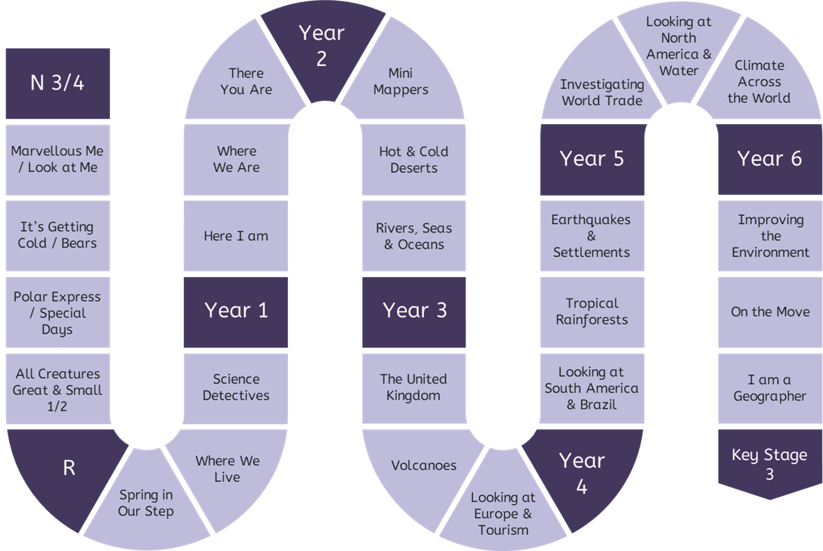
Curriculum Overview Grid 2024-2025 (Academic Year).
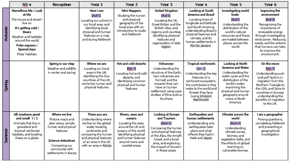
Geography in context.
Geography is taught in 4-lesson units, once a term (Geography alternates with History).
The United Curriculum is sequenced so that meaningful links are made between subjects, and the order of units allows these connections to be made. For example, pupils are taught about the Vikings in Britain in History in Spring 2, so that they can review and build upon knowledge of migration – and consider the push and pull factors behind Viking migration – after they have been taught about migration in Geography in Spring 1.
The United Curriculum for Geography has been adapted for Victoria Road by bringing in the geography of our local area and considering the context of our pupils and the community.
In EYFS, (Nursery and Reception) Understanding of the world involves guiding children to understand their physical world and their community. E.g. visiting a park, a library, meeting an important member of society such as a police officer, listening to stories and non-fiction books to learn about the world around them extends their familiarity with words.
For example:
-
Children in Nursery will experience learning about families around the world or holidays that they have been on, and they will use a diverse range of props and puppets to talk about similarities and differences.
-
Children in reception will draw simple maps including the name of roads, the city they are in and the city their school is located in. They will explore looking at ariel views.
- In Year 1, we consider the local geography of our area by learning about maps and plans. First, we use knowledge gleaned from plans to locate our school within the local area, and we move on to using the children’s own knowledge of the area to devise a route to school with key features of the local area to guide them.
- In Year 1, we further consolidate our knowledge of our local area by comparing it to other areas. This requires us to have collated data on physical and human geographical features and to understand why our area is unique to us.
- In Year 2, we revisit the local geography in our ‘Mini Mappers’ unit and extend our understanding by undertaking fieldwork into a specific enquiry about issues that are relevant to the community.
- In Year 3, we use OS maps to locate and identify human and physical features of the local area. Children are encouraged to use their own knowledge and observational knowledge to identify areas from the OS map and to understand the difference between human and physical geography.
- In Year 5, locational knowledge is used to address the issue of fair trade and the availability of imported food in our community - our knowledge of OS maps from year 3 is revisited and consolidated as we identify where we can buy fair trade goods in the city.
- In Year 6, we adapted to further consolidate our knowledge of the local geography and extend our understanding by undertaking a neighbourhood environmental investigation, addressing issues around migration in our local community and finally, an enquiry into the pupil’s choice to be undertaken within the locality.
- Alongside these specific variations, high quality teaching will incorporate rich and varied discussions from the children and the staff about their knowledge and experiences to provide further depth to our geographical learning.
Implementation: What do we teach and when?
The implementation of the United Curriculum for Geography reflects our broader teaching and learning principles, as follows:
For Geography in particular:
- Content is always carefully situated within existing schemas. For example, map skills cannot be covered in a single task, concepts of map skills are built on methodically and logically over time through careful planning. In the early years, pupils begin to identify features of their local area. In KS1, pupils apply directional vocabulary to features and in KS2, pupils use map symbols and grid references on OS maps to describe the location of features.
- Vertical concepts are used within lessons to connect aspects of learning. For example, when learning about migration, pupils will review population structures, natural hazards and types of settlement when looking at the reasons why people voluntarily or forcibly move from one place to another.
- Opportunities for extended, scholarly writing appear throughout the curriculum. These have a clear purpose and audience and, crucially, allow pupils to write as a geographer. For example, after considering the hazards and benefits associated with volcanic activity and the ways in which humans can prepare for volcanic events, pupils write a discussion explaining why they would or would not live near a volcano.
Impact: How do children show that they know and remember more?
The careful sequencing of the curriculum – and how concepts are gradually built over time – is the progression model. If pupils keep up with the curriculum, they make progress. Formative assessment is prioritised and is focused on whether pupils are keeping up with the curriculum.
In general, this is done through:
- Questioning in lessons. Teachers check understanding so they can fill gaps and address misconceptions as required.
- Pupil conferencing with books. Subject leads and SLT talk to pupils about what they have learnt – both substantive and disciplinary knowledge – and how this connects to the vertical concepts that they have been developing in previous years and other subjects. For example, pupils in year 4 may be asked to talk about the tropical rainforest biome is similar and different to hot and cold deserts, and how these biomes are affected by human activity such as deforestation or migration.
- Post-learning quizzes at the end of each unit. These give teachers an understanding of the knowledge that pupils can recall at the end of the unit, and can be used to identify any remaining gaps to be filled. These are generally simple recall questions. Such as key places or features, using map skills, identifying the causes of flooding or the effects of an earthquake.
- Pre-learning quizzes at the start of each unit. These assess pupils’ understanding of the prior knowledge that is required to access the new content in the unit. These are used to identify gaps to be filled prior to teaching the new unit. For example, in a unit about improving the environment in Year 6, pupils need to recall knowledge about the effects of climate change and non-renewable energy use and apply this to new knowledge about renewable energy and mitigating the impacts of climate change. This knowledge is assessed in the Pre-Learning Quiz, and teachers can plan to fill any identified gaps.
